The headquarters of Kartverket, the Norwegian Mapping Authority, sit on a hill above the small town of Hønefoss, about an hour northwest of Oslo. The building is unremarkable. The work inside it is not.
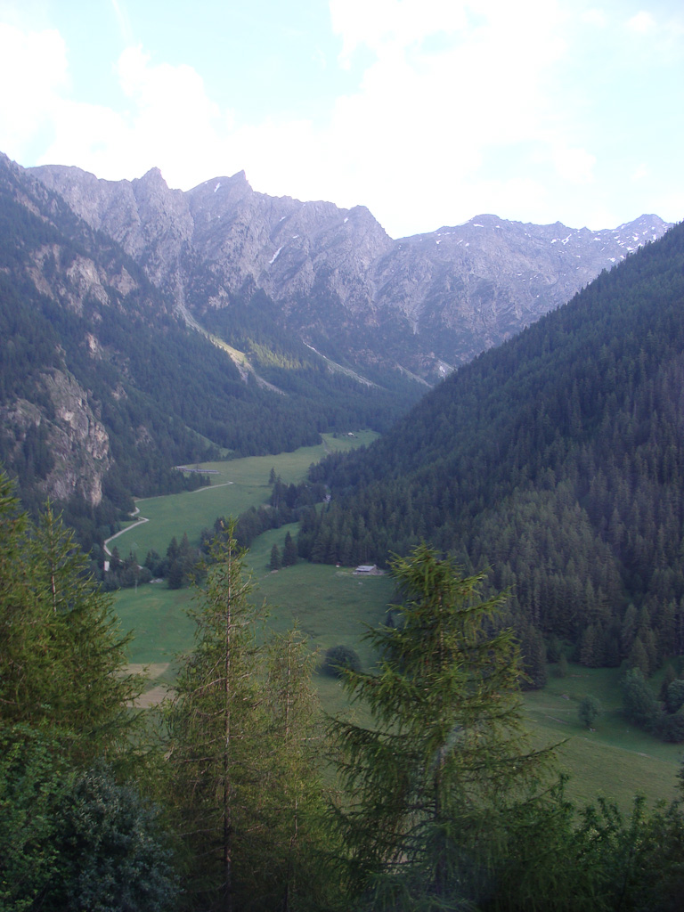
Since 2019, Kartverket has been re-mapping the Jotunheimen, the high massif at the centre of southern Norway that contains the country's twenty-nine summits above 2,300 metres. The project, which is expected to run until 2029, is the most thorough revision of the range's cartography since the 1950s.
The 1950s revision, conducted between 1947 and 1958, was the work of a team of military surveyors led by Major Olav Thommessen. Thommessen and his team walked the entire massif, plane-table in pack, and produced the contour lines that have been in use, with minor amendments, for seventy years.
The Thommessen contours are still admired in the Norwegian cartographic profession. They have a particular character: rounded where the rock is rounded, angular where the granite has weathered into blocks. The lines have a quality of acquaintance.
They are also wrong in many places. The Norwegian glaciers, like the Alpine and Sierran glaciers, have retreated substantially since the 1950s. The Smørstabbreen, west of Galdhøpiggen, has lost perhaps a third of its 1950 extent. The Storbreen has shrunk by a similar fraction.
On the printed map, the glaciers are still drawn at their 1950s extents. The blue ice symbol covers ground that has been bare scree for a decade or more.
This is the principal task of the Kartverket revision. The contour lines, where they describe rock, are largely correct. The lines, where they describe ice, are obsolete.
The project leader, Karoline Bråten, is a 42-year-old cartographer who came to Kartverket in 2011 from a glaciology post at the University of Bergen. She is, by background, both a mapper and a scientist of the thing being mapped. The combination is unusual.
Bråten's team is small: four cartographers based at Hønefoss, two field surveyors based at Lom (the small town at the northern edge of the Jotunheimen), and a contracted aerial survey arrangement with the Norwegian Polar Institute.
The field surveyors, Erik Nordby and Ingrid Skjeldrum, spend roughly 120 days a year in the massif. They ski in early spring, when the snow is firm and the glaciers can be surveyed without crossing the active ice. They walk in late summer, when the rock is dry and the lines can be measured against the foot.
On May 24, the two of them set out from the Spiterstulen hut for a four-day survey of the eastern face of Galdhøpiggen. The face contains two glaciers, one of which, the Svellnosbreen, has retreated by an estimated 280 metres since the last full survey.
Nordby, who joined Kartverket in 2015, said the retreat is visible year to year. "I have skied this face since I was a boy. The ice has gone back, in my lifetime, the length of a long football pitch."
The new map will show the 2025 ice margin, dated. Kartverket has decided that all glacier outlines, on the new Jotunheimen sheets, will be printed with a year next to them. The convention is borrowed from Swiss practice.
The dating acknowledges what the agency cannot avoid: the line will be wrong again within a decade. The reader is informed of the line's vintage.
"We are no longer pretending to draw a stable feature," Bråten said, in a conversation at Hønefoss on May 28. "We are drawing a moment."
The new sheets will also revise the elevations of three summits whose ice caps have melted away. Galdhøpiggen, formally the country's highest peak at 2,469 metres, retains its elevation because its summit is rock. Glittertind, formerly listed at 2,470 metres because of its ice cap, will be listed in the new sheet at 2,452 metres, the height of its highest rock.
This is a small change with a long argument behind it. The Norwegian Mountaineering Association, the DNT, has resisted the relisting on cultural grounds. Glittertind, in Norwegian climbing tradition, is one of the two great summits of the south.
Bråten said the argument is genuine and unresolved. Kartverket, for now, will publish both elevations on the new sheet: the 2,452-metre rock height and a notation that the historic ice cap reached 2,470 metres.
The first new sheets are expected in 2028. They will replace, slowly, the seventy-year inheritance of Major Thommessen. The Thommessen contours, where they remain accurate, will remain on the page. The glacier outlines, where they have receded, will be redrawn with a date next to them.
The map will be smaller in some places and more honest in all of them.